


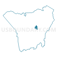
Voting District MG, Henderson County, North Carolina
About
Outline

Summary
| Unique Area Identifier | 640462 |
| Name | Voting District MG |
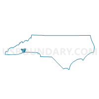
| County | Henderson County |
| State | North Carolina |
| Area (square miles) | 1.88 |
| Land Area (square miles) | 1.87 |
| Water Area (square miles) | 0.02 |
| % of Land Area | 99.13 |
| % of Water Area | 0.87 |
| Latitude of the Internal Point | 35.33066660 |
| Longtitude of the Internal Point | -82.43116620 |
Maps

Graphs
Select a template below for downloading or customizing gragh for Voting District MG, Henderson County, North Carolina


Neighbors
Neighoring Voting District (by Name) Neighboring Voting District on the Map
- Voting District CC, Henderson County, NC
- Voting District HV-2, Henderson County, NC
- Voting District NB, Henderson County, NC
- Voting District NE, Henderson County, NC
- Voting District SB, Henderson County, NC
- Voting District SE, Henderson County, NC
Top 10 Neighboring County Subdivision (by Population) Neighboring County Subdivision on the Map
- Hendersonville township, Henderson County, NC (47,527)
- Blue Ridge township, Henderson County, NC (11,172)
- Clear Creek township, Henderson County, NC (6,011)